
How LiDAR Technology is Transforming Driverless Cars
Lidar (Light Detection and Ranging) is revolutionizing industries around the globe by introducing new levels of precision, automation, and innovation.
This cutting-edge sensor technology uses laser light to measure distances and generate detailed 3D maps of surroundings. Its role has been particularly transformative in enabling autonomous vehicles to navigate complex environments safely and efficiently.
With its ability to provide real-time, highly accurate data, Lidar technology has become a cornerstone of self-driving cars, ensuring they can handle intricate urban landscapes with unparalleled accuracy.
However, the role of Lidar extends far beyond the automotive sector. From urban planning and forestry to archaeology and robotics, Lidar systems are redefining the way we engage with and understand our world.
This article explores the fundamentals of Lidar technology, traces its evolution, highlights its applications, and delves into how it is reshaping industries beyond automotive uses.
Fundamentals of Lidar Technology
Lidar, an active remote sensing technology, operates by emitting laser pulses to measure distances and construct detailed 3D representations of objects and surrounding environments.
Its ability to capture high-resolution spatial data has led to its widespread adoption across multiple industries, including environmental monitoring and vehicle automation.
How Lidar Works
The operation of Lidar systems begins with the emission of rapid laser pulses. These pulses strike objects and reflect back to the sensor, where the system calculates the "time of flight"—the duration for the pulse to return.
Using the speed of light as the reference, Lidar systems can precisely estimate the distance to objects. This process is executed millions of times, producing a detailed 3D "point cloud" map of the environment.
Lidar systems rely on lasers operating within specific wavelengths in the electromagnetic spectrum, such as near-infrared, visible, or ultraviolet light. Common wavelengths include 532 nanometers (nm), 905 nm, and 1550 nm.
The choice of wavelength often depends on environmental conditions and application requirements. For example, a system may use a wavelength optimized for detecting details in dense foliage, while another focuses on mapping urban structures.
Types of Lidar Systems
Lidar systems are categorized based on their beam-steering methods and technical design. Each type has unique strengths suited for specific applications:
Mechanical Lidar Systems
Mechanical systems use rotating mirrors or scanners to direct laser beams, enabling coverage across wide angles. Their broad field of view makes them ideal for applications such as autonomous vehicles and aerial mapping, where environmental awareness is critical.Solid-State Lidar Systems
Unlike mechanical systems, solid-state Lidar leverages non-mechanical methods like optical switches or phased arrays for beam steering. With no moving parts, solid-state Lidar systems offer increased durability and reliability, making them suitable for situations requiring long-term stability and usage.Flash Lidar Systems
Flash Lidar illuminates the entire scene in a single pulse, capturing data instantaneously. This high-speed operation is particularly useful in applications such as real-time object detection, including navigation in robotics and autonomous systems.
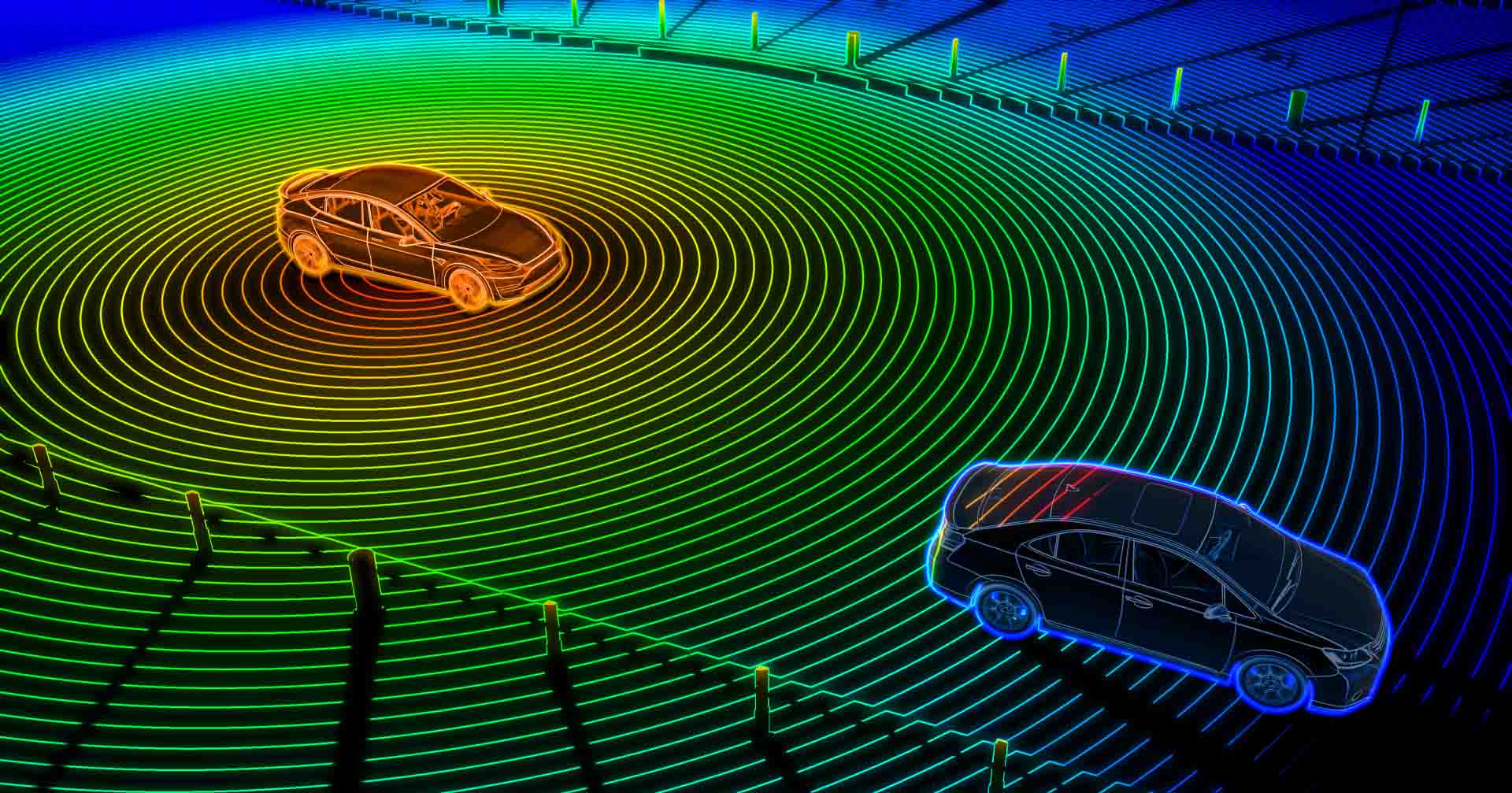
Impact of Lidar on Autonomous Vehicles
Autonomous vehicles depend heavily on Lidar technology to ensure safe and robust navigation. Lidar sensors provide unparalleled data on surrounding objects, enabling these vehicles to detect obstacles, understand traffic patterns, and adapt to ever-changing environments.
By combining high-resolution 3D mapping with real-time precision, Lidar systems empower self-driving cars to operate with a safety standard unprecedented in human-driven vehicles.
Moreover, Lidar is instrumental in addressing edge cases—complex scenarios such as navigating unstructured roads or unpredictable pedestrian behavior.
As advancements in this technology continue, Lidar promises to further enhance the reliability of autonomous transportation systems and accelerate their mainstream adoption.
Lidar Applications Beyond Automotive Uses
While Lidar technology's contribution to autonomous vehicles is widely known, its expanding applications across other industries highlight its transformative potential. Below are some notable sectors leveraging Lidar technology:
Urban Planning
Urban planners utilize Lidar to survey infrastructure and map cities more accurately. With its ability to capture fine spatial details, city governments employ Lidar to plan transportation networks, optimize construction, and monitor environmental impact.
Forestry and Agriculture
Lidar plays a pivotal role in forest management by analyzing tree density, height, and canopy cover. Similarly, in agriculture, it aids in precision farming techniques—like monitoring crop health, managing irrigation systems, and studying soil properties.
Archaeology and Preservation
In archaeology, Lidar is used to uncover ruins concealed under vegetation or challenging terrain. It helps researchers identify sites of historical significance while minimizing disruption to the environment. Furthermore, preservationists use Lidar to meticulously record and monitor historical landmarks for restoration purposes.
Robotics
Robotics is another field benefiting from Lidar's precision mapping and spatial awareness capabilities. Robots equipped with Lidar sensors can navigate difficult terrain, evade obstacles, and perform tasks requiring exceptional environmental understanding.
Environmental Monitoring
From tracking coastal erosion to studying topographical changes, Lidar is crucial for environmental scientists. It enables researchers to monitor natural landscapes and assess the impacts of human activities like deforestation or urbanization.
The Future of Lidar Technology
The evolution of Lidar not only reflects advancements in engineering but also its ability to adapt to diverse industry needs. With the emergence of solid-state systems promising greater affordability and scalability, Lidar applications are likely to see explosive growth.
As costs decline further, industries previously hindered by budget limitations will be able to leverage this transformative technology.
In the automotive sector, Lidar will continue playing a critical role in advancing autonomous vehicle capabilities.
On the global front, its potential applications are endless—from aiding disaster recovery to supporting smart cities and enabling breakthroughs in geospatial technology.
Lidar's future will also depend on concurrent advancements in complementary technologies. Artificial intelligence (AI), machine learning algorithms, and data storage systems are expected to work hand-in-hand with Lidar, enhancing its ability to process and analyze massive amounts of geospatial data quickly and accurately.
Final Thoughts
Lidar technology has rapidly evolved to become a vital tool across a multitude of industries, reshaping how we explore and interact with the world.
From autonomous vehicles and robotics to forestry and historical preservation, this technology's ability to deliver unparalleled spatial insights is driving innovation at an extraordinary pace.
As advancements continue, Lidar is not just shaping industries—it’s enabling a smarter, safer, and more sustainable future.

Post a Comment